
Negro Settlement 1885
Source: Washington: U.S. Department of the Interior, General Land Office, 1885
While looking at a number of old maps of Indian Territory recently, a good friend and colleague, author Art Burton pointed out an historic African American settlement on Indian Territory and Oklahoma Territory maps. Now this is not unusual for Oklahoma's history especially since Oklahoma has had more all black towns than any other state in the country. And about 8 of those towns still exist today. However, this section of the Territory was not one of those historically black towns.
I looked at a map and found that "Negro Settlement". At first I assumed that this might have been a small group of people who were simply on route to another community, and then I began to look at additional maps over the next 20 years.
As early as 1879 the Negro Settlement began to appear on maps:

Source: U.S. General Land Office Indian Territory Pocket Map 1879
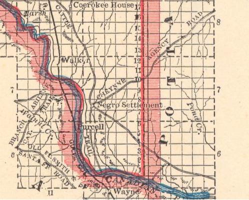
The settlement appeared again in 1887, northwest of Paul's Valley and appeared to be in, or near the Chickasaw Nation. The actual community was in the southwestern corner of what would eventually become Cleveland county, Okahoma. So here, two years later, this community had no name, but was still reflected on local maps.

1887 Map reflecting Negro Settlement
Source: Chicago: Henry S. Stebbins, 1887; From Crams Universal Atlas of the World
Then, in 1889, came a more direct illustration of where this settlement was. At the very end of the old Cheyenne Agency Road.
1889 Image of Negro Settlement
Source: Chicago: People's Publishing Co., 1889
The presence of a cattle trail that ran southeast of the community suggests that this settlement might have been a place where some of the black cowboys may have encamped.

1891 the settlement was still present
Source: Chicago: George F. Cram, 1891
In 1893, there may have been a shift in the population, for the settlement was now reflected on historic maps as merely "huts".

"Huts" described the community in 1893.
Source:Chicago: Rand McNally and Company, 1893;
from Rand McNally and Company's Enlarged Business Atlas and Shippers Guide
In 1901 the settlement was still there, and now also called, Negro Huts

1901 Map reflecting settlement as
Negro Huts
BUT----Interestingly, by the time of statehood, they were gone. No maps represented them, and this settlement that lasted more than 2 decades, was now gone without a trace. It never had a name, and nothing in the current Oklahoma local history represents the presence of this black community. No name---just a reflection of a settlement. My questions is now----where would this settlement be today?
Current maps represent an area not far from the Canadian River, near the point where Walnut Creek flowed into the Canadian River.
The settlement was below Noble Oklahoma and above Purcell, Oklahoma. It was a community to the east of what is now I-35. And---it was at the very endpoint of the old Cheyenne Agency Road.
The problem is today's maps do not reflect the old Cheyenne Agency Road. But thanks to Google Maps one can look at the same area from several perspectives.
1) Several maps reveal that the settlement was near a bend in the Canadian River.
2) The settlement was below Noble, and above what would be come Purcell, Oklahoma
3) There was also the diagonal road coming from a northeasterly direction---the old Cheyenne Agency Road
4) The settlement was also to the east of the river, and to the east of a railroad track that ran directly along the edge of the settlement.
So, using Google Maps I decided to see if I could find a place that met all of those conditions and zoom in .
I could see the bend in the Canadian River.
I could see the bend that was below what is now Noble Oklahoma, and yet above Purcell.
I could see the railroad via a satellite image, and see the area east of the railroad. But---I could not see a road---at least not a current road
However aerial satellite images on that exact same image, do reflect a path of some sort---perhaps an old abandoned trail, coming diagonally from the Northeast that did stop at a point in the same vicinity. The question whether this is the old Cheyenne Agency Trail comes to my mind. And if so...........could this possibly the old Negro Settlement?
Studying the old maps again, the settlement was clearly southeast of Noble, but above Purcell. It appeared to be near a bend in the Canadian River. Today's maps reveal that the settlement was probably west of what is now Slaughterville Oklahoma and Noble.
First, by using Google maps I zoomed in on what might be near that same community.

Then I looked via satellite image also reflects this same area:

I noted on one of that 1889 maps that reflected a point at the end of the old Cheyenne Agency Road.
Could I find that road today coming from a 45 degree angle and ending at the settlement? And if the road no longer exists is it now just an old abandoned trail? I decided to compare the old map with a satellite image of today. I also noticed on the old maps there was a railroad that also ran alongside the settlment.
I needed to find a point alongside the railroad where an old road or trail ended--coming from a 45 degree angle. And it had to be someplace in or near the bend in the Canadian River, and above the town of Purcell.
So looking at an old map, next to a satellite image I studied more:


Then I zoomed in on the same area, inside of the bend of the Canadian River, to the east of the railroad, and at what appears to be the end of a road or trail coming at a 45 degree angle:
The railroad is visible on the left. Two roads intersect--- Banner Road and Burkett Road This area is south and west of Noble Oklahoma, and north and west of Purcell.. Right where the two roads intersect--one can see that the trial did continue a few yards, towards the railroad. Could that possibly be the old Cheyenne Agency Trail? If it is, then the old Negro settlement might have been right there. On some of the maps it also appeared to be a stop of some sort for the railroad.
Looking more closely at the satellite image I zoomed in for a closer look:

Areal view of Burkette and Barnett Road.
Source: Google Maps Satellite Image
Could this be near the old settlement?
(Is the diagonal path on the landscape coming from the northeast a remnant
of the old Cheyenne Agency Road?)
Of course I cannot say with certainty that this is the site of the old settlement---but just in case it was, I wanted to have a look at the site.
So with Google Street View, I decided to take a look and descended through the wonderful technology that exits, to see what was there. At the intersection of Burkett and Banner Road. One can see traces of an old road. Is this possibly the end of the old Cheyenne Agency Road?

Looking North on Burkett Road at intersection
of Burkett and Banner
About 100 feet from the same intersection on sees a small oil pump, and nothing else.

Oil well pumping on near Burkett and Banner Road in Pottawatomie County
between Noble and Purcell Oklahoma
Source: Google Street View Image
Did I really find the remains of the old Negro Settlement? Who were the people who lived there for almost 30 years? Where did they go? What were their stories?
I have no way of really knowing. And unless a team of specialists in land topography, as well as archeologists explored the area, there would be no way of ever knowing the real answer of where the old settlement was.
However, I still appreciated exploring the landscape, with maps and images, and I found that the act of even just searching for remnants of the past, to be one that was humbling nevertheless. Somewhere in this vicinity I can say that there was a community of people of African descent that lived for almost 3 decades near the banks of the Canadian river. Though this was a community that was short lived, it was there, nevertheless.
Who knows what stories came from that old settlement, and whatever happened to the people?
I like to think that perhaps on warm Oklahoma summer evenings, when the wind blows softly, whispers of the ghosts of those long gone, tell their sweet secrets to the breeze and the trees.
Whatever happened to them, may they rest in peace, and may history still tell their story. I was compelled to write a small haiku about this long lost place.
The Old Settlement
Only maps show they were there.
Ghosts now tell the tales.
©Angela Y. Walton-Raji
